


 Bus timings from Hyderabad to Nirmal and vice versa.
  Sri Krishna Residency, Hotel
(Opp: Nirmal Toys Showroom, Nirmal)
Sri Krishna Residency, Hotel
(Opp: Nirmal Toys Showroom, Nirmal)


Adilabad Information
History
ADILABAD DISTRICT, A BRIEF HISTORY.
1.Adilabad was formerly called Edulapuram. The district derived its name as Adilabad, named after Ali Adil Shah the Ruler of Bijapur that was its head quarters. Adilabad district is situated between 77. 46 and 80 of the eastern longitudes and 18.40 and 19.56 of northern latitudes .It is surrounded by Yeotmal and Chandrapur district of Maharashtra towards north, Chandrapur in the East, by Karimnagar and Nizamabad in the South and by Nanded district in the west.
ANCIENT PERIOD:. The district was reigned by various dynasties - viz. Mauryas, Satvahanas Vakatakas, Chalukyas of Badami, Rashrakutas, Chalukyas of Kalyani, Yadvas of Devagiri, Kakatiyas, Bahamanis, Imad - Shahis of Berar, Nizam - Shahis of Ahmednagar , Mughals, Bhonsle Rajas of Nagpur and Asaf - Jahis besides the Gond Rajas of Sirpur and Chanda (Chandrapur).
The history of Adilabad district is connected with the hoary past of the Gondvana and Berar regions (now Vidarbha). The boundries of Gondvana were the River Godavari in the South, and in the North the Central India up to the river Chambal, the Maharashtra State in the West and Agency areas in the East. Berar was probably extended over the Taluqs of Boath, Utnoor, Adilabad, Kinwat and Rajura. In the modern times, major portions of Berar and Gondavana, gradually merged into Maharashtra and Madhya Pradesh states, while lower part came into erstwhile State of Hyderabad which consisted of parts of Karnataka, Marathawada and Telengana.
Though no direct evidence relating to history of periods of Mauryas, Sathvahanas and their successors Vatakas, Chalukyas, Rastrakutas is available, the region appears to have been under the sway of Bhoja Kings whom the epics and Kautilyas Arthashastra locate in the Deccan.
MEDIEVAL PERIOD: The areas of Sirpur, Asifabad, Chinnur, Nirmal and Luxettipet were under the Kakatiyas. The Gond kings established their power over this district for nearly five Centuries during 1240 to 1750 A.D. The Gond chiefs who were related to the rulers of Chanda (Chandrapur) made their base in minor forts of Adilabad District, particularly in magnificently built Manikgarh fort now in Chandrapur district. In 1323 A.D. the district was under the reign of the Sultan of Delhi Mohammed.Bin - Taughlaq who appointed Malik Maqbool as Governor of this region who administered the province from Warangal. Allauddin Hasan Bahaman Shah (1347 - 1358 A.D) the founder of Bahamani dynasty divided the kingdom into four large provinces, one of which comprising Berar and Mohore was placed under the charge of Safdar Khan Sistani. During the Bahamani rule, the fort of Mohore frequently figured to fortify the forts of Berar region, against the danger of invasions from Malawa, Khandesh etc. After his death his son Salabat Khan was appointed as Governor of Berar in 1398 A.D. The Sultan moved from Mohore to Ellichpur (Now Achalpur of Amaravati Dist - Maharashtra) and engaged the enemies in the battle.
Mohd.Gawan divided the Bahamani kingdom into eight provinces of moderate size. The province of Berar was quite large and extended far south till Godavari. It was divided into two provinces - Gavilgarh (now in Amaravati District) and Mohore now in Nanded district. The province of Mohore, which was included what is now in Adilabad district, remained a separate administrative unit under Bahamani for a short period. The internal dissension and quarrels among the various claimants to the Nizam Shahi throne brought about the Mughal invasion on Nizam Shahi dominions. As per the treaty between Mughals and Nizams Shahis on 16th March 1596,possession of Berar by the Mughals was agreed in return to withdrawal from the rest of the kingdom. Thus the region round Manikgarh and strip of south territory of Penganga including Utnoor came under the Mughals. In 1687 A.D. Qutub Shahi ruler - Abul Hasan Tana Shah was defeated and his Kingdom was merged with the Mughal emperor by Aurangazeb. This resulted in the annexation of left over territory in the district.
MODERN PERIOD: Aurangzeb handover the administration of the district along with other Subhas to the officer called Viceroy of the Deccan. The Mughal Deccan at that time consisted of 6 Subhas of which Berar was one. Taking advantage of these changes, the Gonds attempted to capture the fort of Manikgarh. In 1724 A.D Nizam-e-Mulk defeated Mubariz Khan and took possession of the Deccan and began to rule. In 1773 Madhoji Bhonsle entered into an agreement with Nizam Ali Khan, Nizam of Hyderabad by which he agreed to cede Manikgarh (Rajura of Chandrapur) with surrounding territories south of Penganga to the Nizam, in return for the forts of Gavilgarh and Narnala of Amaravati district - Berar. As a result of war between the British and Raghoji Bhonsale II, the latter ceded the territory of Berar to British who, in turn passed it on to Nizam under treaty and obligation for cooperation in war. Consequently Sirpur the ancient seat of Gond Rajas passed into the hands of Asaf Jahi rulers. In 1853 A.D. a treaty was concluded between the Nizam and East India Company, according to which Nizam assigned Berar and other Districts to East India Co. in lieu of expenditure incurred on the Nizam's contingent. The people of all classes in the Nizam dominions very keenly felt the loss of Berar. In 1860 revolt existed against The British .In Adilabad district, the Rohilas & Gonds under Ramji Gond's leadership revolted The British, which was suppressed by the then administrators at Nirmal. Komram Bhimu a tribal led the struggle against Nizam govt. organized the tribals, brought awareness among them about their rights and fought for their rights through guerilla wars in agency areas. The fight lasted till Komran Bhimu was killed in 1940. In the history of Adilabad Komram Bhimu has a unique place for spear - heading the struggle against the then Govt.In commemoration of Komram Bhimu Jathra is being held at Jodeghat and Babejhari areas on full moon day of Ashwiyuja Month Every year. 7. The freedom struggle in the district became an integral part of the Indian freedom movement. Khailafat Agitation Supported by Mahatma Gandhi in 1920 was observed. In 1930 sister Organisations / Sanghams sprang into action all over Telengana for grant of representative Govt. The agitation for a democratic form of Govt. led in 1938 A.D. The Nizam of Hyderabad agreed only after Police Action in 1948 to merge his dominion with Indian Union and thus bringing this district into the democratic country.
ADMINISTRATION: Originally this was not a full-fledged district but a sub district name Sirpur - Tandur. Which was created in 1872 A.D with Edlabad (Adilabad),Rajura & Sirpur as its constituent Taluqs. In 1905 Adilabad became an independent district with head quarters at Adilabad adding Nirmal and Narsapur taluqs of Nizamabad (Indur) and Chinnur & Luxettipet taluqs from Karimnagar (Elganda) District. In 1905 the Adilabad dist was comprised of 8 Taluqs Viz 1 Rajura 2 Adilabad 3 Sirpur 4 Jangaon 5 Luxettipet 6 Chinnur 7 Nirmal and 8 Kinwat. Jangaon was later changed as Asifabad in 1907. In subsequent decade the Taluqs were again rearranged to enable the constitution of two new taluqs - Utnoor & Boath. By 20th Century a part of the District i.e. Boath, Utnoor, Adilabad, Rajura and Kinwat was under the rule of the Yadavas of Devgiri. The temples of Unkeshwar (now in Nanded district), Narayanaswamy at Jainad, Others Temples at Chandur and at Someshwar of Rajura Taluq, temples of Vishnu or Vithala are few remnants of the influence of Yadavas of Devgiri. Mohore fort was built or repaired by Ramadeva or Ramachandra, the Yadava ruler. 9. In 1913-14 A.D. the Head quarters of Adilabad District was shifted to Asifabad due to administrative reason, which continued till 1940-41 where after Adilabad continued to be the District Headquarters. Under the states Reorganisation Act 1956, Adilabad district lost Marathi speaking Taluqs of Rajura and Kinwat & Islapur circle of Boath taluq to Bombay -bi-lingual state, (now Maharashtra state) but gained from Mudhol Taluq of Nanded District, the three revenue circles of Mudhol, Kubeer & Bhainsa. The territorial set-up of 10 taluqs & 3 revenue divisions inclusive of an independent sub-taluq Khanapur continued for longer period. In 1980s Khanapur sub taluq became full-fledged Taluq while Wankadi Taluq was formed out of Asifabad Taluq, Making total (11) taluqs in the district In the Year 1985 on 25th May, the (11) taluqs with 48 revenue circles (Firkas) were reorganized and made into (52) Revenue Mandals & Mandal Parishads, with Mandal Revenue Officers & Mandal Parishad Development Officers as its heads in place of age-old Tahsildars & Block Development Officers.In the year 1987 and 1989 two revenue divisions Utnoor and Mancherial respectively were formed carving out of the existing three revenue divisions. Thereafter no territorial changes took place in the administrative set up.
GEOGRAPHICAL:The Satnala (Satpura) range traverses the District from the northwest to southeast for about 281.5 Kms. In this range the Mahboobghat is the highest peak.The most important river that surrounds or drains the district is Godavari, whereas Penganga, Wardha, Pranhita Kadam and Peddavagu are the tributories of Godavari. Satnala, Swarna and Suddavagu are the rivulets.
GEOLOGY/ ZOOLOGY: Important deposits of coal, limestone, iron-ore and cement-grade lime stone and clays are found besides several other Minerals. The district is important for fuel and timber. Nearly forests cover 40% of the land surface. The wild animals like tiger, panther, leopard, hyena, wolf, jackal, fox, sloth-beer, (Elugubunti), wild boar, Indian bison, Neelgai, deer, sambar, Zinka and spotted deer had been once rich in number now have been gradually decreased after man's rehabilitation in jungles, advent of jeep & rifle and ruthless destruction of forest.
WEATHER: The average rainfall of the district is 995 m.m., the annual rainfall of the district is 700 to 1200 m.m. The temperature of the district during May, the hottest month crosses to 46C, while in December, the coldest month it will be minimum being less than 10C.
ADILABAD MUNCIPALITY: A Municipality Committee was constituted in Adilabad town in 1942-43. Under the Hyderabad Municipality and Town Committee Act 1952, Elections on adult franchise were held for the first time in 1952 when the Committee was formed with 17 elected and 7 nominated members (four non officials and three officials). It became City Municipality under the Hyderabad Dist.Municipalities Act of 1956. Subsequently elections were conducted in 1962 and 1967. Under the AP Muncipality Act 1968, the strength of council was raised to 23 with elected 20 and 3 non �officials consisting - MLA, MLC and Alderman. At present the strength of Council is 32 including 1 Chairman who is directly elected and three co-opted members.The only water supply Scheme in the District was provided (PWS) in 1939-40 for Adilabad Municipality, which was designed to serve 20,000 population @ 15 gallons per capita per day for which source of water supply has been Mavala tank located at 5 Kms. away from town. In 1980s the Adilabad water supply scheme was augmented by taking water from Sathanala river, a perennial source to meet the increasing requirement of drinking water.
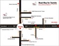
Tourist Guide
Adilabad Travel Guide - Tourist Roadmap